Skip to content


Unveiling the Secrets of the Deep: Bathymetric Survey

As water gently laps the nearby shore, our survey team is met again with zealous curiosity to piece together an underwater puzzle. Through bathymetric surveying, they can unravel the mysteries of the river bottom. Hidden landscapes beneath the swift body of water come to life through state-of-the-art sonar equipment. 

Our geomatics team utilizes advanced sonar equipment mounted on crewed and uncrewed boats. The sonar emits sound waves that travel to the river banks and bottom and bounce back, allowing the survey team to create accurate depth measurements. Combining these measurements with positioning data, we create detailed maps of underwater terrain like ponds, rivers, and lake bottoms.

One of the standout features of bathymetric surveying is the emphasis on accuracy—the precision provided by the sonar equipment. The bathymetric data collected is highly reliable. This accuracy is essential for various applications that rely on precise underwater topography information.

Why Would You Need a Bathymetric Survey?

Bathymetric surveying has a wide range of applications, and our team's expertise caters to several crucial needs. These include:

Reservoir Capacity Measurement

Accurate bathymetric data assists in calculating the volume and capacity of reservoirs. This information is invaluable for water resource management.

Reservoir Dredging Planning
Bathymetric surveys are pivotal in planning reservoir dredging projects. The detailed underwater maps guide the dredging process, ensuring efficient removal of sediment and debris.
Flood Inundation Studies

Understanding the underwater topography is crucial for predicting flood patterns and assessing potential inundation areas. Bathymetric data is used in modeling flood scenarios and developing effective mitigation strategies.

Bridge Structure Sizing

For bridge construction, having precise knowledge of the water body's depth is essential. Bathymetric surveys aid in determining the appropriate sizing and design of bridge structures, ensuring safety and stability.

Construction Boring
Before beginning construction projects involving water bodies, such as pipelines, knowing the underwater terrain is essential. Bathymetric data assists in planning construction activities, preventing potential issues, and ensuring successful project execution.

Lake Bathymetric Survey

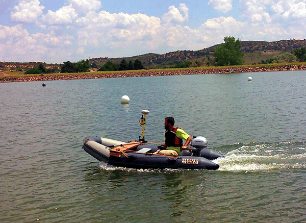
Our geomatics team at Lamp Rynearson brings a wealth of expertise to projects. Our proficiency in mounting sonar equipment, conducting surveys, and processing data ensures that clients receive comprehensive and reliable bathymetric information.

Our team is committed to assisting clients with their bathymetric surveying needs. By offering accurate and detailed underwater maps, we contribute significantly to various sectors, including environmental management, infrastructure development, and disaster preparedness.

If you select us for your next bathymetric surveying project, it will encompass cutting-edge technology, accuracy, and a diverse array of applications. Our survey team is ready to deliver high-quality data for reservoirs, flood studies, construction projects, and more.

Our professionals are ready to help, reach out today!